-
Rain, drop in temperatures and first snow in the extreme north of the country
- September 10, 2024
The weather conditions in the Peninsula include a series of phenomena that will impact the coming days. This Tuesday, the rains will continue in the north, while some regions of the Mediterranean , such asMallorca,MenorcaandGirona, will activate alerts in the event of dangerous waves . The State Meteorological Agency (AEMET) has indicated an approach of aDANA(Isolated High Level Depression) to the northwest, although it is not expected to cause significant impacts.
The northern end of the Peninsula will continue to suffer the influence of a humid flow , which will result in overcast skies and light rain, especially in the Cantabrian area. Showers are likely to be recorded in regions such as Galicia, the western Pyrenees and the Iberian system. On the other hand, occasional rain could also affectBalearesand to the east ofCataluña.
The arrival of the DANA will increase cloudiness in the interior and southeast of the Peninsula, generating possibilities of isolated storms in areas such as the Central System and the Montes de Toledo. At the same time, temperatures will experience a decrease in the northern third and the Mediterranean area, while they will increase in the rest of the country. The cities that will have the highest temperatures will beMurciaat 34ºC,Córdobawith 33ºC, andBadajoz,Ciudad Real,SevillaandToledoreaching 32ºC.
A cold front will arrive on Wednesday, bringing with it a wave of heavy rain in Galicia, the Cantabrian Sea and the Pyrenees. As the remains of the DANA move, showers and thunderstorms are likely to occur in eastern Andalusia, Murcia, and the Valencian Community, as well as inBalearestowards the end of the day. Precipitation is expected to intensify in Valencia and Alicante.
On Thursday and Friday, although the rains will continue, they are expected to decrease in intensity, affecting mainly the northern half of the Peninsula and some areas of the Mediterranean. A mass of polar air will enter after the passage of the front, causing a significant drop in temperatures.
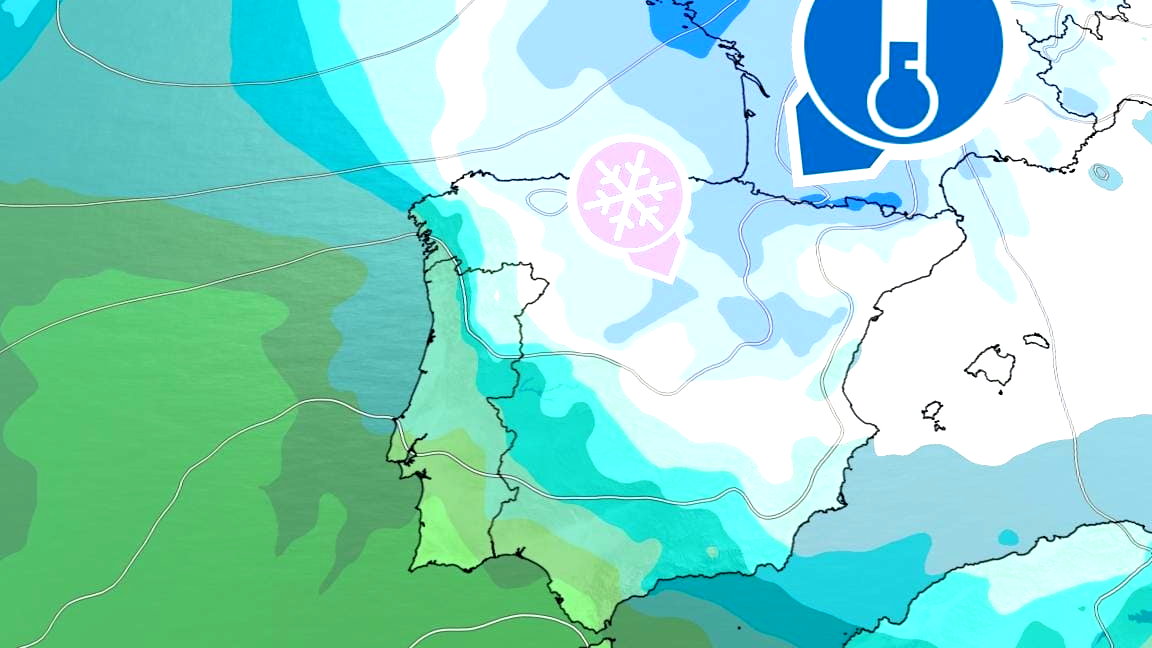
The AEMET has warned that from Thursday, Spain will feel the impact of an “unusually cold” air mass for this time of year, significantly affecting theIslas Balearesand vast areas of the north of the peninsula. With this situation, the first snowfalls are expected in the Pyrenees, where the snow level could be between 1,400 and 1,800 metres, and frost is likely to be recorded in various mountain ranges.
However, this drop in temperatures will begin to fade on Saturday, with an expected rise in the thermometer, especially in the west of the peninsula. This will be a necessary relief, exceeding the normal values for this time of year.
Friday is expected to be one of the coldest days, with lows ranging between 5 and 9 degrees in cities such asÁvila,Bilbao,Burgos, and other localities. In contrast, in some areas of the south, such asBadajozandSevilla, maximum temperatures could exceed 30 degrees.
From now on, temperatures are expected to continue to be cooler than usual in regions of theCantábrico oriental, the northeast of the peninsula and the coasts of theComunidad ValencianaandBalearesHowever, a decrease is projected in the southern third and an increase in the rest of the Peninsula and in the archipelagos.
On the contrary, the forecast from eltiempo.es indicates that, starting on Thursday, maximum temperatures in the northern half are expected to fall below 20ºC, with thermal anomalies ranging between -10ºC and -12ºC in mountainous areas of the north. This meteorological scenario is a reminder of the variability of the climate and how atmospheric phenomena can rapidly change conditions in our region.
Comentar: